2 Introduction, scope and approach
This is a data-led risk assessment using the most recent five calendar years of incident data on casualties, fatalities, type and location of incident and of demand on LFB resources. This layer highlights risks which are relatively common under normal requirements, with likelihood of incidents occurring forming a key metric. “Normal requirements,” is a term used in the Fire and Rescue Services Act 2004 to describe the level of “personnel, services and equipment” that should be provided for firefighting and road traffic accidents. Less frequently occurring events which would cause significant harm or damage outside of normal requirements are considered in layer three.
Risk Matrices
In this layer incidents can score high for consequence on the risk matrices due to the number of resources that were deployed to an incident or because of the casualty rate of a given incident type. By having two metrics for consequence the approach captures incidents that have a relatively low resource draw but a high casualty rate, such as persons trapped in road traffic collisions, and incidents such as fires in rural areas that have a relatively low casualty rate but a high draw on resources. Both incident types present risk to the community of London in their own way.
This report includes two different risk matrices. The different presentations allow the same incident data to be viewed in different ways by different intended users. Risk is presented by location and building type in Risk Matrix 1. This is intended for users where the geography or location of a risk is important, for instance, understanding the distribution of risk between different property types or highlighting risks associated with rural areas. For users where the geography is less important, and it is the specific activity that is relevant, Risk Matrix 2 shows incident risk data by the LFB Incident Type Code (ITC). This presentation allows users to focus on incident types that have high casualty rates such as “C3 Acid attack on a person” that are less visible in the location-based data, as they are not constrained by building type or location and may occur anywhere.
Geographic disposition of risk
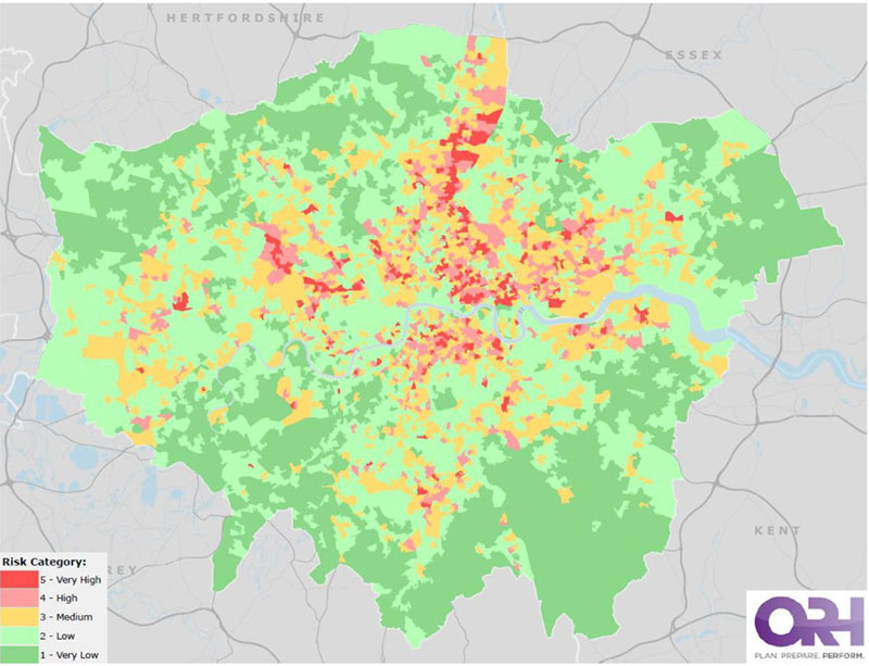
The Brigade uses methodology developed by the NFCC to highlight the geographic distribution of indicators for increased risk related to dwelling fires, non-dwelling building fires and road traffic collisions (RTC). Dwelling fire risk is calculated using correlation between demographic factors and fire risk to assign a geographical area with a fire risk rating. The approach uses national incident data and is developed by the NFCC. In this document the NFCC methodology using Lower Super Output Areas, (LSOAs) has been selected. This was chosen by LFB as sufficiently granular for understanding the distribution of dwelling fire risk pan-London.
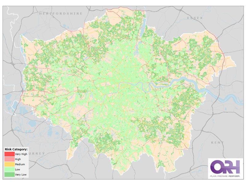
A similar approach is used to map road traffic collision (RTC) risk but using features of the road network to correlate with risk rather than demographic factors.
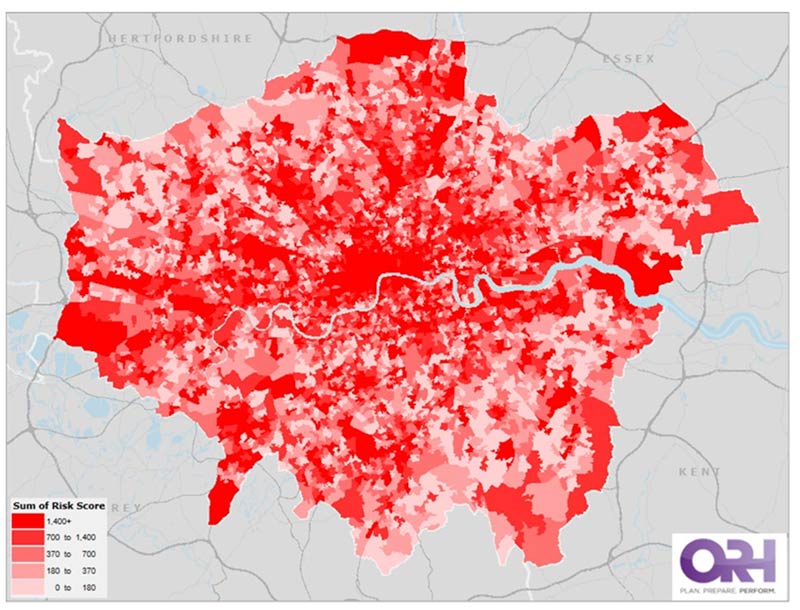
The NFCC has developed a methodology for non-dwelling fire risk which remains unpublished. LFB has adopted the draft approach to understand the geographic distribution of non-dwelling building fire risk.
Because new census and index of multiple deprivation data sets have become available since the production of NFCC methodologies, where possible, LFB has replaced the original data sets with the most up to date available.
To aid understanding of geographic distribution of hazards other than fires and RTCs. LFB has used the highest scoring risks from risk matrix two and analyses the distribution of these pan-London at station ground resolution. This allows more granular understanding of the distribution of risks such as acid attacks, people collapsed behind locked doors and people in crisis.
Geographic disposition of demand.
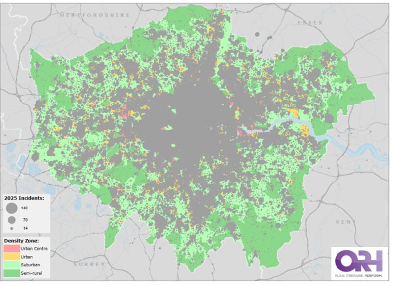
LFB has developed an approach to illustrate where demand for services predominantly occur and where different types of risk proxy are concentrated. We term this approach, Neighbourhood Density Zones. These are broadly concentric zones of similar population density.
3 Objectives
The purpose of layer two is to:
- assess which property types and locations are associated with the most demand and most casualties under normal requirements.
- assess which specific incident types are associated with the most demand and most casualties under normal requirements.
- assess which property types and locations and which incident types, have the potential for the greatest local impacts and resourcing implications for LFB under normal requirements.
- inform prioritisation of resources based on current highest risks.
4 Limitations
Recent incident data does not account for rare or extreme events that have not occurred in the data capture period or may have never happened. These events are assessed in layer three.
Incident data is inherently backwards looking, it is a lagging indicator of risks that have already occurred. Horizon scanning for new and emerging risk and assessment of trends is presented in layer four.
Because incident data is a lagging indicator it may underrepresent rapidly changing risks where historic averages appear stable but key drivers have changed.
Data sources that record cause of fire and items most commonly involved in fire are not presented in this layer. These data are tracked and reported by LFB fire investigation and they are fed into layer four of this assessment where trends of increasing risk and demand are identified. This is why Lithium-ion or e-bike fires do not appear in this layer but are reflected in Layer four.
5 Key Findings
Risk likelihood and Severity
- Reduced risk from fires in houses and bungalows. Reductions are observed in the likelihood based on 5 years incident data.
- Fires in Purpose built flats remain the highest risk fire type and have not followed the downward trend in numbers of fires overall or in the reduced severity scores noted in other locations.
- The risk associated with fires in care homes have increased, driven by an increase in the severity score of the risk indicating a higher rate of casualties than in the past.
- Special service (non-fire) risks have increased across multiple location types
- B11, collapsed behind locked door incidents, and Persons Trapped RTCs remain the highest non-fire risk incidents from 2025
- B12 Incidents, persons threatening to jump has maintained the raised position noted in 2025 indicating a sustained increase in this risk.
Highlighted specific risks – Lithium-ion involved fires.
Lithium‑ion battery fires, including those involving e‑bikes and e‑scooters, were identified in the Brigade’s 2025 Assessment of Risk as an emerging risk, reflecting public and professional concerns about battery safety and the wider adoption of lithium‑ion energy systems. The continued rise in incidents confirms this developing trend, although the overall number remains low relative to total fire activity in London. Where these incidents occur, they may intersect with existing vulnerability factors, particularly in domestic settings. Given the increasing use of lithium‑ion powered transport and energy storage, the risk profile is expected to remain dynamic and will continue to be considered within the broader category of risks associated with new fuels and emerging technologies.
Geographic disposition of risk
The following high and very high-risk incident types are concentred in specific areas of London;
- Dwelling Fire Risk - Dwelling fire risk largely aligns with areas of most population density and with areas that align geographically with areas of higher multiple deprivation. There is a central risk disposition with spread and outlying pockets focussed on areas of development and density and deprivation.
- Road Traffic Collision - Road traffic collision risk is concentrated towards the periphery, most notably around arterial and ring roads entering and circling London.
- Non-Dwelling Building Fire – Is distributed more widely across London
- High risk incident type clusters. Paddington, Lambeth, Soho, Ilford, Tottenham, Dagenham, North Kensington, Plumstead, Poplar and Holloway station grounds are associated with clusters of high-risk incident types. Each of these geographic areas has a cluster of four or more individual high and very high-risk incident types that occur significantly more than the brigade wide average (two standard deviation above average).
- A1HR (Fires in high rise buildings) has a large central London bias with Paddington’s station ground having a rate of more than five times the brigade wide average.
- B1T incident types, involving people under trains are concentrated centrally with Soho’ station ground accounting for more than nine times the brigade wide average.
Geographic disposition of demand
Overall demand for services occurs primarily in areas of higher population density.
6 Risk Matrices
Incident risk matrices and trends in incident likelihood and severity for all incident types and locations can be viewed by LFB staff using this live report.
Risk Matrix One: Incident Risk by Type and Location
Status: Red
Fire - Care and supported living
Fire - Farming and agriculture
Fire - Food and Drink
Fire - Manufacturing and processing
Fire - Retail
Non-Fire - Boat
Non-Fire - Outdoor water
Non-Fire - Trains
Non-Fire - Vegetation by road, track or canal
Severity score: 5 (on a scale of 1-5 where 5 is the highest option)
Likelihood score: 2 (likely frequency of incidents occurring within London)
Fire - House or Bungalow
Fire - Private garage, shed or outbuilding
Non-Fire - Transport buildings
Severity score: 5 (on a scale of 1-5 where 5 is the highest option)
Likelihood score: 3 (likely frequency of incidents occurring within London)
Fire - Purpose built flats
Severity score: 5 (on a scale of 1-5 where 5 is the highest option)
Likelihood score: 4 (likely frequency of incidents occurring within London)
Non-Fire - Road Vehicle
Severity score: 5 (on a scale of 1-5 where 5 is the highest option)
Likelihood score: 4 (likely frequency of incidents occurring within London)
Fire - Converted flats and HMOs
Non-Fire - Rural land
Severity score: 4 (on a scale of 1-5 where 5 is the highest option)
Likelihood score: 3 (likely frequency of incidents occurring within London)
Non-Fire - Urban infrastructure
Severity score: 4 (on a scale of 1-5 where 5 is the highest option)
Likelihood score: 4 (likely frequency of incidents occurring within London)
Non-Fire - Converted flats and HMOs
Non-Fire - House or Bungalow
Non-Fire - Purpose built flats
Severity score: 4 (on a scale of 1-5 where 5 is the highest option)
Likelihood score: 5 (likely frequency of incidents occurring within London)
Status: Amber
Fire - Other residential property
Fire - Warehouses and bulk storage
Non-Fire - Camping tent, shelter or marquee
Severity score: 5 (on a scale of 1-5 where 5 is the highest option)
Likelihood score: 1 (likely frequency of incidents occurring within London)
Fire - Other non-residential property
Fire - Public administration, utilities and amenities
Fire - Short stay accommodation
Non-Fire - Other residential property
Severity score: 4 (on a scale of 1-5 where 5 is the highest option)
Likelihood score: 2 (likely frequency of incidents occurring within London)
Fire - Road Vehicle
Fire - Rural land
Fire - Urban infrastructure
Non-Fire - Communal living
Non-Fire - Entertainment and culture
Non-Fire - Hospitals and medical care
Non-Fire - Manufacturing and processing
Non-Fire - Private garage, shed or outbuilding
Non-Fire - Sports and leisure
Non-Fire - Warehouses and bulk storage
Severity score: 3 (on a scale of 1-5 where 5 is the highest option)
Likelihood score: 3 (likely frequency of incidents occurring within London)
Non-Fire - Education
Non-Fire - Food and Drink
Non-Fire - Offices and call centres
Non-Fire - Retail
Non-Fire - Short stay accommodation
Severity score: 3 (on a scale of 1-5 where 5 is the highest option)
Likelihood score: 4 (likely frequency of incidents occurring within London)
Non-Fire - Care and supported living
Severity score: 3 (on a scale of 1-5 where 5 is the highest option)
Likelihood score: 5 (likely frequency of incidents occurring within London)
Status: Yellow
Fire - Boat
Non-Fire - Static Caravan, Houseboat, towing caravan
Severity score: 4 (on a scale of 1-5 where 5 is the highest option)
Likelihood score: 1 (likely frequency of incidents occurring within London)
Fire - Aircraft
Fire - Communal living
Fire - Entertainment and culture
Severity score: 3 (on a scale of 1-5 where 5 is the highest option)
Likelihood score: 1 (likely frequency of incidents occurring within London)
Fire - Hospitals and medical care
Fire - Landfill or wasteland
Non-Fire - Car park and transport
Non-Fire - Farming and agriculture
Non-Fire - Other non-residential property
Non-Fire - Urban furnishings
Severity score: 3 (on a scale of 1-5 where 5 is the highest option)
Likelihood score: 2 (likely frequency of incidents occurring within London)
Fire - Education
Fire - Offices and call centres recycling
Fire - Transport buildings
Non-Fire - Aircraft
Severity score: 2 (on a scale of 1-5 where 5 is the highest option)
Likelihood score: 2 (likely frequency of incidents occurring within London)
Non-Fire - Public administration, utilities and amenities
Severity score: 2 (on a scale of 1-5 where 5 is the highest option)
Likelihood score: 3 (likely frequency of incidents occurring within London)
Fire - Refuse, rubbish or recycling
Severity score: 2 (on a scale of 1-5 where 5 is the highest option)
Likelihood score: 4 (likely frequency of incidents occurring within London)
Status: Green
Fire - Camping tent, shelter or marquee
Fire - Religious
Fire - Sports and leisure
Fire - Static Caravan, Houseboat, towing caravan
Severity score: 2 (on a scale of 1-5 where 5 is the highest option)
Likelihood score: 1 (likely frequency of incidents occurring within London)
Fire - Barbeque
Fire - Car park and transport
Fire - Trains
Severity score: 1 (on a scale of 1-5 where 5 is the highest option)
Likelihood score: 1 (likely frequency of incidents occurring within London)
Fire - Urban furnishings
Fire - Vegetation by road, track or canal
Non-Fire - Barbeque
Non-Fire - False Alarm - Property not found
Non-Fire - Landfill or wasteland
Non-Fire - Religious
Severity score: 1 (on a scale of 1-5 where 5 is the highest option)
Likelihood score: 2 (likely frequency of incidents occurring within London)
Non-Fire - Refuse, rubbish or recycling
Severity score: 1 (on a scale of 1-5 where 5 is the highest option)
Likelihood score: 3 (likely frequency of incidents occurring within London)
Risk Matrix Two: Incident Risk by Incident Type Code
Status: Red
A4: Fire Involving HazMat - including cylinders
B10: Person in Precarious Position requiring immediate rescue
B1: Person Trapped (Not RTC)
B1T: Person under Train/Tram
C3: Acid Attack on Person
G11: NILO Assessment - Nil attendance
J0: FBT Running Call received from MCA
J1: Midstream Incident on the Thames
J3: Person/Animal in Waterway/on Foreshore
RTC: ROAD TRAFFIC COLLISION
VEHICLE: Vehicle fires
Severity score: 1 (on a scale of 1-5 where 5 is the highest option)
Likelihood score: 2 (likely frequency of incidents occurring within London)
B19: Assist Ambulance with Bariatric/Difficult removal of Patient
C1: HazMat
N0: Nil Attendance
Severity score: 1 (on a scale of 1-5 where 5 is the highest option)
Likelihood score: 3 (likely frequency of incidents occurring within London)
A1HR: Fire in High Rise
RTC Persons trapped
Severity score: 1 (on a scale of 1-5 where 5 is the highest option)
Likelihood score: 4 (likely frequency of incidents occurring within London)
A1: Fire - including large vehicle fires
B11: Person Collapsed or Injured behind locked door
Severity score: 1 (on a scale of 1-5 where 5 is the highest option)
Likelihood score: 5 (likely frequency of incidents occurring within London)
B12: Person Threatening to Jump or Assisting MPS with Persons at Height
Severity score: 4 (on a scale of 1-5 where 5 is the highest option)
Likelihood score: 3 (likely frequency of incidents occurring within London)
B2: Reduced Special Service
MAKE: Make safe - RTC
Severity score: 4 (on a scale of 1-5 where 5 is the highest option)
Likelihood score: 4 (likely frequency of incidents occurring within London)
B3: Effecting Entry - Person Locked
Out/In & Person Collapsed Behind Locked Door
Severity score: 4 (on a scale of 1-5 where 5 is the highest option)
Likelihood score: 5 (likely frequency of incidents occurring within London)
Status: Amber
AMB: Ambulance required for member of Brigade/staff/visitor
B13: Serious Collision involving Brigade vehicle
B14: Minor Collision involving Brigade vehicle
B93: Collapse of Building/Structure (Level 3) - Persons involved
E3: Aircraft Accident/Aircraft Accident Imminent
ES5: Emergency Services Channel
FSG: 1 or more FSG calls in any premise type
G0: Operation PLATO - Nil attendance
J8: Vehicle in Waterway accessible from land
PERSON: Person on Fire - Out in the open
Severity score: 5 (on a scale of 1-5 where 5 is the highest option)
Likelihood score: 1 (likely frequency of incidents occurring within London)
A0: Tests / Exercises No attendance
MULTI: Multi lane make safe - RTC
Severity score: 4 (on a scale of 1-5 where 5 is the highest option)
Likelihood score: 2 (likely frequency of incidents occurring within London)
A8: Fire all Out
Severity score: 3 (on a scale of 1-5 where 5 is the highest option)
Likelihood score: 3 (likely frequency of incidents occurring within London)
A10: AFA Commercial Premises
A11: AFA Residential Premises - for High Rise use A1HR
A2: Reduced Fire Attendance - including electrical junction box
B4: Flooding
C5: Natural Gas Leak
Severity score: 3 (on a scale of 1-5 where 5 is the highest option)
Likelihood score: 5 (likely frequency of incidents occurring within London)
Status: Yellow
B7: Train/Tram Crash
B92: Collapse of Bldg/Structure (Level 2) - No persons involved
Severity score: 4 (on a scale of 1-5 where 5 is the highest option)
Likelihood score: 1 (likely frequency of incidents occurring within London)
MA: Mutual Assistance
Severity score: 3 (on a scale of 1-5 where 5 is the highest option)
Likelihood score: 1 (likely frequency of incidents occurring within London)
A3: Reduced Fire Attendance involving Railway/Tram property
B0: No attendance recommended refer to Supvsr
J12: Person Threatening to Jump from Bridge or Structure on the River Thames
Severity score: 3 (on a scale of 1-5 where 5 is the highest option)
Likelihood score: 2 (likely frequency of incidents occurring within London)
A12: Siege/Person Threatening to set light to themselves or property
B6: Burst Water Main
E1: Aircraft Full Emergency/Ground Incident
Severity score: 2 (on a scale of 1-5 where 5 is the highest option)
Likelihood score: 2 (likely frequency of incidents occurring within London)
C2: Fuel Spill up to 100 litres
Severity score: 2 (on a scale of 1-5 where 5 is the highest option)
Likelihood score: 3 (likely frequency of incidents occurring within London)
Status: Green
C4: Mercury Spill
J2: Houseboat/Vessel Sinking/Flooded Accessible from land
Severity score: 2 (on a scale of 1-5 where 5 is the highest option)
Likelihood score: 1 (likely frequency of incidents occurring within London)
A7: Fire on Vessel - accessible by land
AFR: Alleged Fire Risk
B17: Large Animal Rescue - Including if waterway involved
C11S: HazMat - British Transport Police Support
CNAT0: Mass Decontamination National Initial Call
D1: Fire in Road/Rail Tunnel
D3: Sub Surface incident
FFEM: Firefighter Emergency
G6: Op Hasani/Wide Area Search
J4: HazMat incident on Thames
J7: Fire on Vessel on Thames
Severity score: 1 (on a scale of 1-5 where 5 is the highest option)
Likelihood score: 1 (likely frequency of incidents occurring within London)
AFA: ITC as per SECH flowchart
B8: Commercial Flooding
Severity score: 1 (on a scale of 1-5 where 5 is the highest option)
Likelihood score: 2 (likely frequency of incidents occurring within London)
B2E: Person Shut in Lift - Emergency
B2NE: Person Shut in Lift - Non Emergency
Severity score: 1 (on a scale of 1-5 where 5 is the highest option)
Likelihood score: 4 (likely frequency of incidents occurring within London)
7 Geographic disposition of risk – NFCC Definition of Risk: Dwelling Fire Risk Map
8 Geographic disposition of Risk - Non-Dwelling Building Fire
9 Geographic disposition of risk – NFCC Definition of Risk: Road Traffic Collision Risk Map
10 Geographic disposition of risk – high and very high-risk incident types
A1: Fire - including large vehicle fires
Risk level:
- Very High
Geographic distribution (> 2x standard deviation from Brigade wide average):
- North Kensington, Tottenham, Plumstead, Paddington, Dagenham
B11: Person Collapsed or Injured behind locked door when called by LAS or MPS
Risk level:
- Very High
Geographic distribution (> 2x standard deviation from Brigade wide average):
- Tottenham, Paddington, Dagenham
A1HR: Fire in High Rise Flats/Commercial Buildings - 6 floors and above
Risk level:
- Very High
Geographic distribution (> 2x standard deviation from Brigade wide average):
- Paddington, Poplar, Lambeth, Shoreditch
B3: Effecting Entry - Person Locked Out/In & Person Collapsed Behind Locked Door
Risk level:
- Very High
Geographic distribution (> 2x standard deviation from Brigade wide average):
- Stoke Newington, North Kensington, Tottenham, Holloway
PERSONS: Persons trapped - RTC
Risk level:
- Very High
Geographic distribution (> 2x standard deviation from Brigade wide average):
- Croydon, Enfield, Hayes, Heathrow, Orpington
B2: Reduced Special Service - including ceiling plaster/trees/roof tiles/bldg fascia/aerials etc in precarious position & person collapsed or injured in street etc.
Risk level:
- Very High
Geographic distribution (> 2x standard deviation from Brigade wide average):
- Paddington, Hammersmith, Soho
MAKE: Make safe - RTC
Risk level:
- Very High
Geographic distribution (> 2x standard deviation from Brigade wide average):
- Croydon, Ilford, Southgate, Stanmore
B19: Assist Ambulance with Bariatric/Difficult removal of Patient
Risk level:
- Very High
Geographic distribution (> 2x standard deviation from Brigade wide average):
- Barking, Plumstead, West Norwood, Woodside
C1: HazMat - including cylinders/refrigerant leaking/Fuel Spill over 100 litres - inside or outside
Risk level:
- Very High
Geographic distribution (> 2x standard deviation from Brigade wide average):
- Lambeth, Paddington, Lewisham
B12: Person Threatening to Jump or Assisting MPS with Persons at Height
Risk level:
- Very High
Geographic distribution (> 2x standard deviation from Brigade wide average):
- Ilford, Poplar, Lambeth, Euston
A4: Fire Involving HazMat - including cylinders and explosions
Risk level:
- Very High
Geographic distribution (> 2x standard deviation from Brigade wide average):
- Tottenham, Southall, Plumstead, Old Kent Road, Ilford, Dagenham, Bethnal Green
B1: Person Trapped (Not RTC)
Risk level:
- Very High
Geographic distribution (> 2x standard deviation from Brigade wide average):
- Soho, Tooting, Stoke Newington, Erith
B10: Person in Precarious Position requiring immediate rescue
Risk level:
- Very High
Geographic distribution (> 2x standard deviation from Brigade wide average):
- Soho, Tooting, Holloway
B1T: Person under Train/Tram or Person Struck by Train/Tram
Risk level:
- Very High
Geographic distribution (> 2x standard deviation from Brigade wide average):
- Soho, Paddington, Lambeth, Holloway, Euston
C3: Acid Attack on Person
Risk level:
- Very High
Geographic distribution (> 2x standard deviation from Brigade wide average):
- Orpington, West Hampstead, Willesden, Stratford, Lambeth, Fulham
J1: Midstream Incident on the Thames
Risk level:
- Very High
Geographic distribution (> 2x standard deviation from Brigade wide average):
- Lambeth, Dowgate, Twickenham, Soho, Dockhead
J3: Person/Animal in Waterway/on Foreshore
Risk level:
- Very High
Geographic distribution (> 2x standard deviation from Brigade wide average):
- Poplar, Lambeth, Dockhead, Stratford, Millwall
VEHICLE: Vehicle fires - Small/Large & Incidents involving vehicles
Risk level:
- Very High
Geographic distribution (> 2x standard deviation from Brigade wide average):
- N/A
MULTI: Multi lane make safe - RTC
Risk level:
- High
Geographic distribution (> 2x standard deviation from Brigade wide average):
- Hayes, Enfield, Poplar, Hendon, Ilford, Mill Hill, Barking
B93: Collapse of Building/Structure (Level 3) - Persons involved
Risk level:
- High
Geographic distribution (> 2x standard deviation from Brigade wide average):
- N/A
E3: Aircraft Accident/Aircraft Accident Imminent
Risk level:
- High
Geographic distribution (> 2x standard deviation from Brigade wide average):
- Hillingdon
FSG: 1 or more FSG calls in any premise type
Risk level:
- High
Geographic distribution (> 2x standard deviation from Brigade wide average):
- N/A
J8: Vehicle in Waterway accessible from land
Risk level:
- High
Geographic distribution (> 2x standard deviation from Brigade wide average):
- Chiswick, Hillingdon
PERSON: Person on Fire - Out in the open
Risk level:
- High
Geographic distribution (> 2x standard deviation from Brigade wide average):
- Paddington
A10: AFA Commercial Premises
Risk level:
- High
Geographic distribution (> 2x standard deviation from Brigade wide average):
- Soho, Euston, Dowgate
A11: AFA Residential Premises - for High Rise use A1HR
Risk level:
- High
Geographic distribution (> 2x standard deviation from Brigade wide average):
- Paddington, Chelsea, Hammersmith, North Kensington, Euston, West Hampstead
A2: Reduced Fire Attendance - including electrical junction box
Risk level:
- High
Geographic distribution (> 2x standard deviation from Brigade wide average):
- Dagenham, Soho, Wennington, Orpington, Ilford, Plumstead
B4: Flooding
Risk level:
- High
Geographic distribution (> 2x standard deviation from Brigade wide average):
- Bethnal Green, Paddington, North Kensington, Lambeth, Stoke Newington, Tottenham
C5: Natural Gas Leak - commercial or residential
Risk level:
- High
Geographic distribution (> 2x standard deviation from Brigade wide average):
- Paddington, Stoke Newington, Tottenham
11 Highlighted specific risks – Lithium-ion involved fires.
Lithium‑ion battery fires, including those involving e‑bikes and e‑scooters, were identified in the Brigade’s 2025 Assessment of Risk as an emerging risk, reflecting public and professional concerns about battery safety and the wider adoption of lithium‑ion energy systems. The continued rise in incidents confirms this developing trend, although the overall number remains low relative to total fire activity in London. Where these incidents occur, they may intersect with existing vulnerability factors, particularly in domestic settings. Given the increasing use of lithium‑ion powered transport and energy storage, the risk profile is expected to remain dynamic and will continue to be considered within the broader category of risks associated with new fuels and emerging technologies.
12 Geographic disposition of risk – high and very-high risk incident distribution by LFB station ground
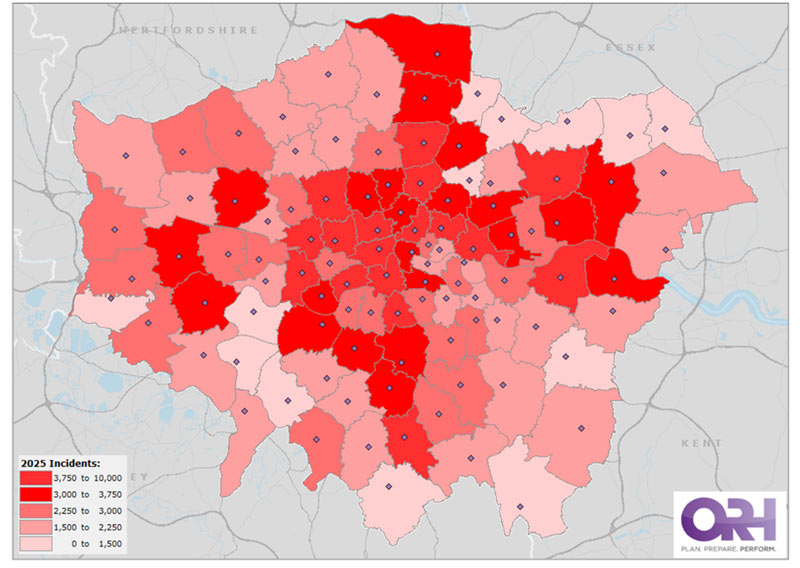
13 Geographic disposition of demand and population density
Population density by LFB, “density zone”
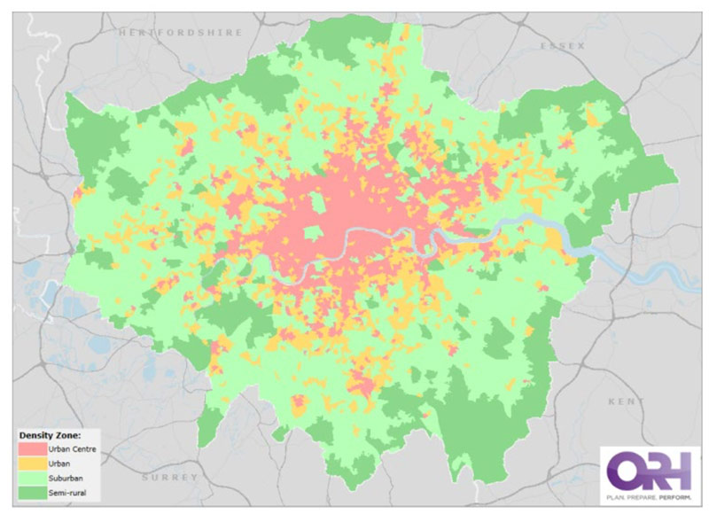
2025 all incidents overlay on density zone base map.